
Manaslu Circuit Trekking
Destination
Nepal
Duration
17 Days
Difficulty
Strenuous
Max Altitude
5,106 m
Accomodation
Lodge/Tea House
Best Season
Mar-May Sep-Nov
Trip Start
Pokhara
Trip End
Pokhara
Overview of Manaslu Circuit Trekking
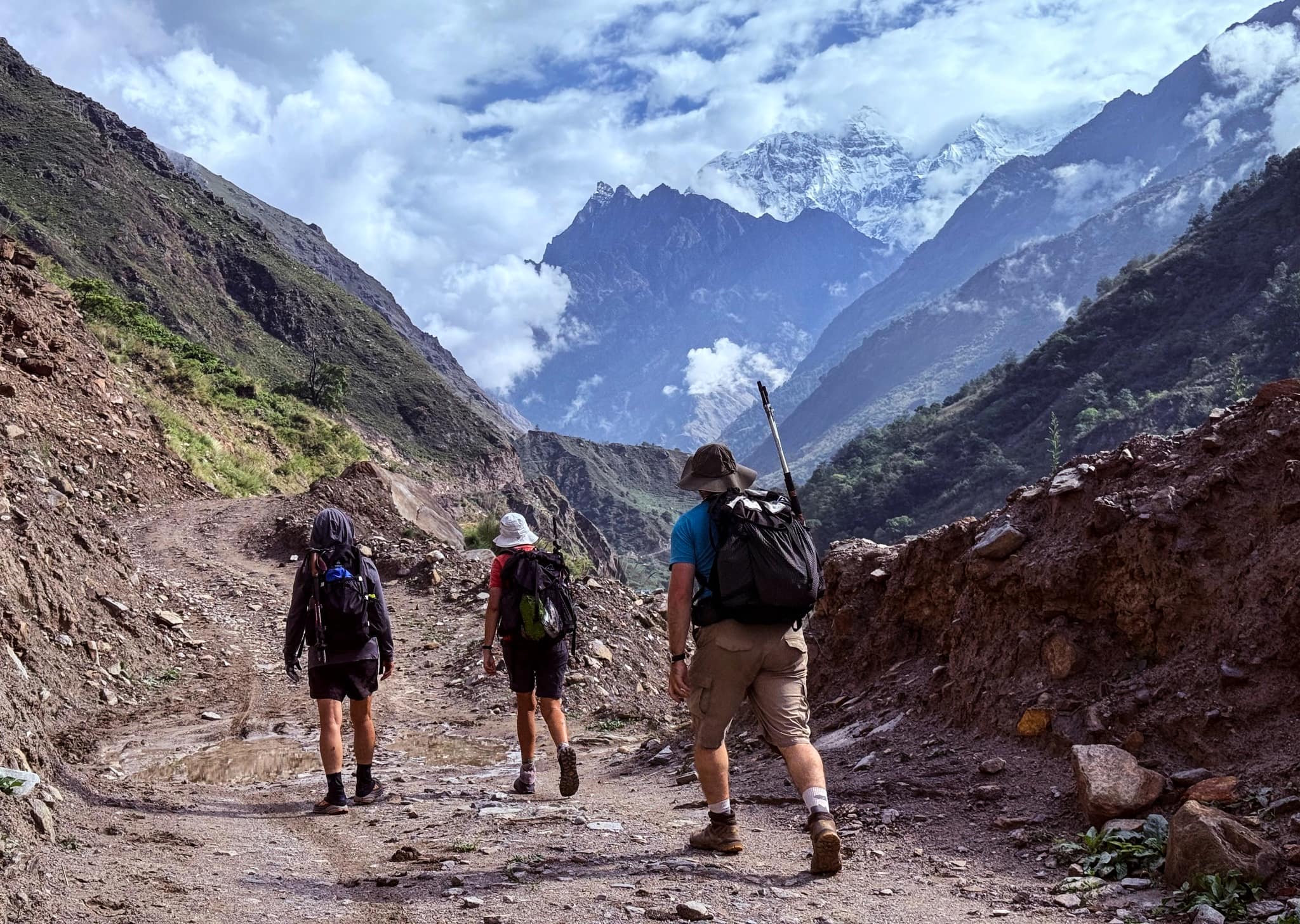
This trek offers great views of the highest mountains (like Syaula Peak, Naike Peak, Manaslu, Himchuli, Larke Peak, Cho Peak), cultural heritage, a genuine outing in the wilderness, bio-diversity, incomparable scenery beauty, epic suspension bridges and many more. The local inhabitants and their cultures and traditions are also major attractions. Excellent Nepalese-styled houses and hotels accommodating different services may attract you to spend time there as well. But you can also spend nights in tents/camps and enjoy the natural Nepal under billions of stars.
In 1991, the Manaslu locale trekking is opened. This trek furnishes astounding excellence alongside the outskirts of Nepal and Tibet. Mount Manaslu is one of the mountains which exceeds the height of 8000m, standing at an altitude of 8163m. A great part of the trek includes strolling on the mountain premises; going through various customary towns, forests alongside the lovely perspective of various cascades, mountain peaks, etc. which makes your trip all the more fascinating and memorable.
Less Crowded Trails for a Peaceful Journey !
The Manaslu Circuit Trek is less crowded than other hiking routes, so you can enjoy peace and quiet. Uncrowded trails allow you to establish a strong connection with the natural world and your journey. It is hence a favorite among those seeking tranquility, contemplation, and a genuine sense of adventure.


Highlights
- Diverse cultures and ethnic groups (Hindu, Buddhist, Bon-Po).
- Stunning views of Annapurna and Dhaulagiri mountain ranges.
- Scenic landscapes: tropical rice fields, Rhododendron forests, Mustang Valley.
- Ancient Tibetan monasteries (e.g., Braga Monastery).
- Muktinath Shrine, sacred to both Hindus and Buddhists.
- Challenging Thorung La Pass (5416 meters).
- Witnessing the ancient Bonpo Religion in Mustang.
- Tibetan cultural influence in Mustang.
- Relaxing end in Pokhara, with a mountain flight from Jomsom.
Itinerary
Day 01: Arrival in Kathmandu – Welcome to the Land of the Himalayas
Upon your arrival at Tribhuvan International Airport in Kathmandu, a representative from Beauty Nepal Adventure will warmly welcome you and transfer you to your hotel in a private tourist vehicle. You’ll receive a short briefing about your trip and meet your guide. Take the rest of the day to relax or explore the vibrant streets of Thamel.
Day 02: Permit and Trek preparation day
After breakfast, you will meet your trekking leader when he will go over what is required for the trek, such as your Manaslu Restricted area trekking permit. You will also need 3 passport-sized photos and a copy of your travel insurance policy.
Prepare for your trek with a comprehensive briefing, ensuring you are fully equipped for the journey ahead. Utilize this day for any last-minute shopping for trek essentials. Additionally, you have the freedom to explore Kathmandu’s cultural sites, such as the historic Durbar Square and the Swayambhunath Stupa, immersing yourself in the local heritage.
Day 03: Drive from Kathmandu to Sotikhola [710m/2328 ft] 8 - 9 hours
Our journey starts today with the drive from Kathmandu to Arughat, which will take around 7–9 hours. The first part of the journey is smooth as we go along the highway. But, from Gorkha or Dhading, the path is rough (there are two ways that go to Arughat). We take some rest before continuing the further journey from Arughat to Soti Khola, changing vehicles. It is approximately 13 km away from Arughat. On the way, after the Kathmandu valley, you will get a beautiful view of the Himalayas like Mt. Annapurna (left view), Manaslu range in the middle and Ganesh Himal in the right.
Day 04: Soti Khola - Maccha Khola [900m/2952 ft]: 6 - 7 hours
From Soti Khola, Machha Khola is 15km away and it will take around 5 hours to reach there. Little further from Soti Khola, there lies an army camp in Lighting and walking further from there will take us to the place named Khursani baari. (Khursani baari means green chili field) You can also view the 100m lengthy waterfall from the opposite side of Khursani baari. Walking on the same side will lead you to Machha Khola. After the massive earthquake of 2015, you will get the shocking landslide view in the area. Nowadays a road facility has developed which was little disturbed by the earthquake. The number of residents in the area is less as we can find just 20-30 houses in the whole area. There also reside 4 popular hotels. Stay overnight at camp in Machha Khola.
Day 05: Maccha Khola -Jagat [1410m/ 4625 ft]: 6 - 7 hrs
After the permit checking in the police checkpoint in Machha Khola, we continued our trial towards Jagat. On the way, we enjoy the bath in the hot spring and move along the steep valley sides. An hour before reaching Jagat, you will have the horizon view of the cantilever bridge from Yaru bagar (which will take 20 minutes to reach there. This cantilever bridge is 158 m long and is considered as the first bridge in Nepal. Jagat is about 22 km away from Machha Khola and will take approximately 7 hours to reach there. After a little walk from the location of the bridge, the sight of Jagat’s field will welcome you for an overnight camp and Tea-house. .
Day 06: Jagat - Deng [1,804m/5917 ft]: 6 - 7 hrs
We continued our trek to Deng early in the morning after the permit check-in at upper Jagat. It is around a seven hours walk to Deng village which is made up of just about 4 houses and 3 hotels. After 40 minutes of walking, on the way to Salleri, you need to cross the one river and you will see the view of milky flow in the river. Before fall you will view two hydro-powers (one new and one old). On the way, you will pass from Salleri to Sirdibas which is inhabited by local Gurung, and overview the mountain named Siring (7239m). After crossing a bridge and walking about 15 to 20 minutes, you will reach Philim, where lie different administrative offices, land revenue offices, police stations, and many more. From Philim we trek to Chisapani. After having lunch in Chisopani we take the path towards Nayak Phedi and further to Pewa which will take about one and half hours to reach there. In Pewa, you will have to cross the suspension bridge 2 times which itself is a nice experience. From Pewa, it will take 45 minutes to Deng. Stay overnight in a Tea-House.
Day 07: Deng - Namrung [2630m/8626ft]: 7-8 hrs
Early in the morning after breakfast, we start our trail downhill to Budhi Gandaki River and uphill to Rana gaon viewing the beautiful landscape and rivers. From Rana gaon, we will reach Bihiphedi after a 45 minutes of walk. From Bihiphedi, we march towards Gap, the lunch place, which will take about 2 hours to reach there. We take lunch there and after lunch, we walk for one hour through the dense forest after crossing the river from old to new, overseeing the dense forest, dead pine tree and many more. We then reach Suksum and from there we climb uphill to Namrung which will take about 1 hour and 20 minutes. After Deng, you can find the people of Tibetan lifestyle and culture. In Namrung you can find a resort and if you want to stay there, it will take 35$ US for room and extra for food. Other mesmerizing views are of Saula Himal, Himalchuli Range. Overall, Namrung is approximately 21 km far from Deng and will take about 7 hours to reach there.
Day 08: Namrung – Samagaon [3530m/11,578 ft]: 6-7 hours
To reach Samagaun from Namrung, you will pass through Banjam, Lihi, Sho, Lho, and Sayla. On the way, before reaching Lho, you will view a monastery which is recognized as the one in the region. In this monastery, more than 200 monks study among whom all are boys. The path towards Lihi is steep and marching there will give you the view of Ganesh Himal, north Himchuli and Naike peak on the right. We continue our trip towards Sho and in the corner, we find two ways, among which one leads to Hinayang monastery and another path leading to Manaslu larkya pass. From Sho, it will take 1 hour 30 minutes to reach Lho and from Lho we trek for 2 hours to reach Sayla. From Sayla, it will take 1 hour to reach Samagaun. From the syala, you will get the panoramic view of north Himalchuli, Nadi Chuli Manaslu, north Manaslu, Nike peak, Saula Himal, and siringi himal. Real yak view is also a major satisfaction. It is the biggest village which originated about 200 years ago from Tibet. It is a popular place for commerce and is the route to Manaslu Base Camp.
Day 09: Samagaun – Samdo (3,860m/12,660ft): 8km, 4 -5 hrs
Descend towards the Budhi Gandaki, which has turned north, and pass the lake and Base Camp trail as well as several mani walls as the valley begins to widen. This is an easy trail along a shelf above the river past juniper and birch forests that surround Kermo Kharka. A stone wall divides the region into two with a stile and animal gate that separates the Sama and Samdo herds. Further on, the trail drops to cross the Budhi Gandaki on a wooden bridge before climbing steeply onto a promontory above the confluence of the river with the Mayol Khola from the Samdo Glacier to the northeast.
At the top is a stone arch, followed by fields before a white kani at the entrance to the village: an attractive, cold, yak and goat herding area. This was an ancient summer grazing region and was only settled in the late 1950s when the residents fled Tibet. They built the clustered dry stone houses with stone-slab roofs along a low ridge with fields below and behind the village. They trade to the north and south.
Zigzag up yak tracks behind the village to any of several sets of flags on a high ridge for superb 270o views: with Samdo Peak (6,335m/20,785ft) and its dramatic glacial basin to the east; the Sama Valley and its ranges to the south (Manaslu is masked by a rocky peak to the southwest); while to the west is a bird’s eye view over the northern Syacha Glacier from Manaslu (partially hidden) and tomorrow’s trail to Dharamsala and the Larkya La. Samdo is the last village before Gho, in the Manang District. Only informal kharkas (with lodges) lie between these villages.
Day 10: Samdo – Larkya Phedi/Dharamsala (4,460m/14,628ft): 7km, 3–5 hrs.
Descend past the northern village fields to cross the Budhi Gandaki for the last time at the remains of the Larkya Bazaar site. The river turns north up the Pana Danda Valley. Follow the westward trail on grassy slopes with scrub juniper, rhododendron and lichen-covered granite above the Syacha Khola Valley. The source of the Syacha Glacier that descends from the Manaslu North ridge comes into sight. The trail works its way gradually up the valley towards the Larkya Glacier beyond the Larkya La Phedi, called Dharamsala. The guest house is a simple stone structure: with a kitchen and dining room, two separate buildings with 15 small double rooms, two tunnel-tents each with 8 cramped beds and a third for trekking staff. Short walks can lead to better views of the Larke (6,249m/20,503ft) and Naike (6,291m/20,641ft) peaks.
Day 11: Dharamsala – Larkya La (5,160m/16,930ft) – Bimthang (3,720m/12,201ft): 12km, 7-9 hrs.
Today’s pass needs, if snow free, 3–5 hours to ascend the 800m/2,600ft to the summit and 3–4 hours to descend the 1,500m/4,900ft to Bimthang. It can be very cold, especially if windy. Snow and ice conditions demand more care and time.
The trail along the northern moraine of the Larke Glacier is not steep or difficult but is long and continuously rocky underfoot. Snow poles line the route. From Dharamsala, it rises gently to a ridge followed by a long gentle climb to the vast and jumbled moraine. Larke Peak on the Larke Himal wall and Pawar Peak on the Cheo Himal emerge to the south and north of the glacier. A short climb leads to an ablation valley followed by a drop to pass the first of four small scattered frozen lakes. A gradual ascent to the left up the glacial moraine and a final pull leads to the first set of summit flags. Back to the east, look over the trail to the Tibetan border ranges beyond Samdo Peak. The Larke Himal wall blocks more southerly views; the Pawar Himal views to the north.
A long moraine-ridge runs from the first flags, parallel to the Larke wall and separated from it by a deep gully, to a second set of flags and astounding views ahead. (These flags also mark the border between the Manaslu and Annapurna Conservation areas.)
To the west, peaks include (anticlockwise from the north) the impressive Pawar Peak (6,620m/21,720ft), Cheo Himal (6,820m/22,376ft), the Himlung pyramid (7,126m/23,380ft), Gyaji Kung (7,030m23,065ft), Kang Garu (6,981m/22,905ft) plus Annapurna II (7,937m/26,041ft) and its satellites away to the east. Below lies a magnificent basin within dramatic rock and ice walls from which flow a complex of glaciers.
The descent begins from these flags and drops steeply off the moraine then traverses loose scree slopes down a set of steep zigzags to the grassy Dangboche Kharka (4,450m/14,600ft) almost directly below.
The trail offers a bird’s eye view of the glacial action that feeds the upper Dudh (milk) Khola. From the Pawar Himal, the Salpudanda Glacier merges with the Ponkar Glacier below the medial Ponkar Lake (trapped between their moraines) and is then joined by the western Kechakyu Glacier to form the Bimthang Glacier that exists in the valley.
From Dangboche Kharka the gradient eases and the trail follows the curve of the lateral moraine of the Salpudanda/Bimthang glacier into the lovely Bimthang Valley. A T-junction indicates a path up over the moraine to Ponkar Lake or down to the scenic settlement of Bimthang (plain of sand). The Kechakyu Himal rises to the north and Manaslu’s northeast face and connecting ranges stand high above the valley to the east. Bimthang is now the summer grazing settlement for the people of Samdo. Before the closure of the Tibetan border, it was an important trading post. The Tibetan Khampa warriors held a center here in the 1970s.
Day 12: Bimthang – Gho (2,515m/8,250ft): 12km, 5–6 hrs.
A further 1,200m/3,900ft descent begins with a walk across the Bimthang Plain, a drop to cross the stony glacier then up and over the far moraine to enter magnificent pristine rhododendron and pine forest. Views back towards the Larke, Manaslu, Nadi and Chuli Himals are excellent all along this route. The trail descends along the west bank of the Dudh (milk) Khola past Hompuk (3,430m/11,254ft, a rock shelter near the bridge) and attractive Sangura Kharka (3,020m/9,909ft) before descending steeply to the highest cultivated land at Karche (2,700m/8,860ft). Beyond is a flood-related landslide, more terraced fields and a steep ridge climb before dropping to the substantial (Gurung) village of Gho.
Day 13: Gho – Dharapani (1,920m/6,300ft): 8km, 3–4 hrs.
After breakfast, trek through farmland to the old paved village of Tilje (2,300m/7,546ft), then cross to the east bank of the river before descending rapidly towards the Marsyangdi Valley through scrub forest. Cross back to the west bank just before Thonje (1,965m/6,447ft) and then, in Thonje, cross the Marsyangdi Khola (from Manang) just above the confluence before joining the new road along the main Annapurna Circuit route in Dharpani at the perfect lunchtime and end of the trek. In the afternoon, enjoy the hot shower and wander around this Tibetan village. Overnight at Lodge in Dharapani Meal: Breakfast, Lunch & Dinner.
Day 14: Drive from Dharapani- Besi Sahar (760m/2,495ft) and drive to Pokhara (1,300m/4,264ft): 190km 6- 7-hrs
It depends on local vehicle and road conditions. After breakfast, slowly ride a jeep along the dusty and bumpy road to BesiSahar via Taal, Chamje ,Syaage. Khudi etc. Or if you wish to walk, then it will take two days to reach Besisahar.
Alternatively, turn west on the paved road to explore the lake city of Pokhara (106km), beneath Mount Annapurna, Mount Fishtail ,Lamjung Himal etc. Overnight at Pokhara
Then, we will celebrate the successful completion of our journey. We will have a farewell dinner at a typical Nepali restaurant in Pokhara where we can pick our typical meals.
Day 15: Free Day in Pokhara – Optional Activities
Take a well-deserved rest day in Pokhara. You can spend the day relaxing by Phewa Lake, boating, getting a massage, shopping for souvenirs, or optionally visiting places like the Peace Pagoda, Davis Falls, or the International Mountain Museum and an early morning hike to Sarangkot viewpoint for sunrise.
Day 16: Fly or Drive Back to Kathmandu / 22 minutes fly and 7 hrs drive by bus
After breakfast, we return to Kathmandu either by scenic flight or by road. Once in Kathmandu, you’ll be transferred to your hotel. Enjoy your last evening in Nepal with time for final shopping or simply relaxing.
Day 17: Final Departure – Until We Meet Again
Today, a representative from Beauty Nepal Adventure will transfer you to the international airport for your onward flight. We hope your journey in Nepal has been filled with joy, wonder, and unforgettable memories.
Thank you for trekking with Beauty Nepal Adventure – we hope to welcome you again !
Note :- This Itinerary is meant only as a guideline and is subject to change to suit the local conditions. Walking hours are based on an average walking pace and may change as per individual pace.
What's include
- Kathmandu Airport pickup and drop.
- As per itinerary accommodation in Kathmandu and Pokhara.
- All accommodation and meals during the trek .
- Meal three times a day during the trek.
- Breakfast, Lunch & dinner, Tea/Coffee.
- Land Transport for both way trek starting and trek ending Point.
- An experienced English-speaking Professional / Competent / Flexible trekking Guide.
- Porters service ( One strong porter service between two clients).
- Including their salary, equipment, transport, food ,lodging ,insurance etc.
- A comprehensive medical kit for Nepali staff.
- All necessary paperwork and permits.
- Special Manaslu trek permit.
- ( MCAP ) Manaslu Conservation Area Park Permit.
- ( ACAP ) Annapurna Conservation Area Park Permit.
- ( TIMS Card ) Trekking Information Management System Card
- Farewell dinner in the evening at Pokhara tricycle Nepali restaurant.
- Government Tax, Vat etc
What‘s excluded
- KTM / Pokhara /KTM flight tickets.
- KTM / Pokhara /KTM Bus tickets.
- Personal & medical insurance during the trip.
- Lunch, dinner and Accommodation in Pokhara and Kathmandu.
- Bar bills & beverages (like mineral water, coke, fanta , rum ,beer etc.
- Tips for Guide and Porter.
- Personal expenses.
Essential Info
Suggested Equipment List
- Duffel/Rucksack bag
- Walking Pole
- Day pack.
- Trekking shoes.
- Sports shoes or sandals.
- Sun Hat/cap
- Warm woolen cap.
- Warm fleece jacket or puffy jacket
- Waterproof Gore-Tex layer
- Pullover or warm sweeter
- Raincoat
- 4/5 pairs of good quality socks
- Hand gloves.
- 2/3 pairs of trekking trousers.
- 3/4 pairs of trekking shirts.
- 3/4 pairs of underwear (non cotton preferred).
- Sun glasses
- Water bottle
- 4 season sleeping bag
- Flash or Torch light
- Camera and batteries
We at Beauty Nepal Adventure understand that every traveler has different dreams, schedules, and expectations when it comes to trekking and exploring Nepal.
That’s why each of our trekking itineraries is flexible and customizable. Whether it’s the duration of the trek, the destination, or the type of experience you’re looking for, we’re more than happy to tailor the journey according to your interests, time availability, and travel preferences.
If you have any specific wishes or suggestions, please don’t hesitate to share them with us. We are always open, friendly and generous when it comes to adjusting our programs to better suit your needs. Your comfort and satisfaction are our top priorities.
Feel free to express your ideas without any hesitation. We genuinely welcome your input.
Thank you for trusting Beauty Nepal Adventure. We look forward to creating a beautiful journey together! Namaste !
Related Packages
- 24 Days
- Streneous
- 5,160m
- 15 Days
- Moderate
- 3,360m