
Manaslu Circuit and Tsum Valley Trek
Destination
Nepal
Duration
24 Days
Difficulty
Streneous
Max Altitude
5,160m
Accomodation
Lodge/Tea House
Best Season
Mar-May Sep-Nov
Trip Start
Pokhara
Trip End
Pokhara
Overview of Manaslu Circuit and Tsum Valley Trek
A Manaslu Tsum Valley trek typically combines the Manaslu Circuit trek with a detour into the remote Tsum Valley, often lasting around 20–24 days. The itinerary involves trekking through diverse landscapes, from lush green valleys to high mountain passes, with opportunities to explore monasteries and experience Tibetan Buddhist culture.
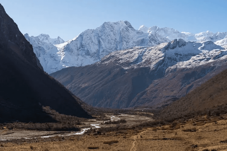
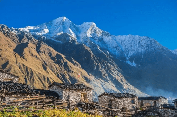
The Manaslu Tsum Valley Trekking takes us on an adventure we’ve never seen before. It represents a journey to some of the most enchanting, alluring, and magnificent High Himalayan peaks and mountain scapes around Manaslu and combines it with the magical scenes of(Hidden Valley) Tsum Valley. Mount Manaslu, the eighth-highest peak in the world, is sure to be one of the main highlights of our Manaslu Tsum Valley Trek.
The Tibetan Buddhist charm of Tsum Valley is incredibly refreshing as well. We start our journey, driving to ASoti Khola from Kathmandu, where the trek starts. Passing through terraced fields and beautiful small villages, we trek past the Budhi Gandaki River, reaching the village of Machhakhola. Then the trek to Tatopani crosses forests and small villages and bestows a hot spring bath to relax a few times.
The Stunning Views of Mt. Sringi Himal accompanies us on the way to Philim. Trekking through Chumling we arrive at Chhokangparo in the Upper Tsum Valley with magnificent views of Mt. Ganesh Himal, Mt. Boudha Himal, and Mt. Himal Chuli. On the trail to the Nile/Chhule, we pass through Piren Phu (pigeon cave), a sacred destination that preserves Buddhist murals, scripts, and old carved stones where we stop for a visit. Then after we stop in Mu Gompa at 3700m, from where we trek to Rachen Gompa, a nunnery. The trek to Gumba Lungdang passes through pine and colorful rhododendron forests, and we cross the Siyar Khola. If you have enough time, you can take a rest to visit Ganesh Himal Base Camp. The trail to Chumling, our next day’s destination, has no proper lodging or facilities, so we start early. From Chumling to Deng, we trek through Gurung and Thakali villages. At Samagaon, we take a rest for another day and hike to Manaslu Base Camp or Pungiyan Gompa trip and explore the village.
We gradually gain altitude from Samagaon to Samdo, Dharamsala, and cross the Larke La pass at 5106m to arrive at Bhimtang, which marks the end of the trip. Then after we will begin our journey back, passing through Besisahar and driving to Pokhara, exploring beautiful tourist places and after a few days later drive or fly to Kathmandu.

Highlights
- Diverse cultures and ethnic groups (Hindu, Buddhist, Bon-Po).
- Stunning views of Annapurna and Dhaulagiri mountain ranges.
- Scenic landscapes: tropical rice fields, Rhododendron forests, Mustang Valley.
- Ancient Tibetan monasteries (e.g., Braga Monastery).
- Muktinath Shrine, sacred to both Hindus and Buddhists.
- Challenging Thorung La Pass (5416 meters).
- Witnessing the ancient Bonpo Religion in Mustang.
- Tibetan cultural influence in Mustang.
- Relaxing end in Pokhara, with a mountain flight from Jomsom.
Itinerary
Day 01: Arrival in Kathmandu – Welcome to the Land of the Himalayas
Upon your arrival at Tribhuvan International Airport in Kathmandu, a representative from Beauty Nepal Adventure will warmly welcome you and transfer you to your hotel in a private tourist vehicle. You’ll receive a short briefing about your trip and meet your guide. Take the rest of the day to relax or explore the vibrant streets of Thamel.
Day 02: Permit and Trek preparation day
After breakfast, you will meet your trekking leader when he will go over what is required for the trek, such as your Manaslu & Tsum Valley Restricted area trekking permit. You will also need 3 passport-sized photos and a copy of your travel insurance policy.
Prepare for your trek with a comprehensive briefing, ensuring you are fully equipped for the journey ahead. Utilize this day for any last-minute shopping for trek essentials. Additionally, you have the freedom to explore Kathmandu’s cultural sites, such as the historic Durbar Square and the Swayambhunath Stupa, immersing yourself in the local heritage.
Trek starting day
Day 01: Kathmandu – Arughat (670m/2,198 ft) – Soti Khola (710m/2,330ft): 135km, 8–9 hrs drive (It depends on local vehicle and Road conditions.)
A westward 70km scenic drive along the Prithvi Highway, through the forested Middle Hills, leads to Malekhu. A 30km secondary tarred road heads north, over the Trisuli Nadi, towards Dhading Besi and a rutted 35km dirt road northwest to Arughat on the Budhi Gandaki. The dirt road winds upwards towards the Gola Bhanjyang where panoramic views of the southern slopes of the Ganesh, Baudha and Manaslu Himals should be possible.
The road then drops to cross the Ankhu Khola and later, at Arughat, the Budhi Gandaki that drains the Manaslu – Tsum region. A further ~3 hrs drive up the west bank of the river leads to Soti Khola.
Day 02: Soti Khola – Machha Khola (890m/2,920ft) 14km, 6-7 hrs
After breakfast, today’s trail rises gradually through beautiful Sal forests. It then undulates over forested and terraced ridges, passing numerous waterfalls. The trail is generally narrow, at times clinging to the sides of cliffs. It later drops to pass rice paddies before climbing to the attractive Gurung village of Labubesi (885m/2,800ft). After crossing a suspension bridge at the spectacular Nauli Khola falls, the valley opens out and the trail drops onto gravel banks along the river before rising slightly to the village of Machha (Fish) Khola.
Day 03: Machha Khola – Dobhan (1,000m/3,280ft):11km, 6–7 hrs
The trail follows the river, with minor ups and downs, often dropping to the gravel bar before crossing the Thado Khola and on up to Khorlabesi, where coffee, buckwheat and tobacco are grown. A trail from Gorkha joins the Manaslu circuit here and the GHT trail turns east from the Manaslu to the Langtang and Everest regions.
Our trail then enters a lush narrow gorge that constricts the river’s progress. Beyond is a landslide with a dicey path, shortly before the triple hot spring spouts in Tatopani. The trail then climbs a ridge before crossing the Budhi Gandaki on a suspension bridge to avoid a huge cliff face and waterfalls. A good staircase leads to a landslide before a final ridge climb to Dobhan.
Day 04: Dobhan – Philim (1,590m/5,216ft): 10km, 6-7 hrs
Exit over the Dobhan Khola and continue up the east bank of the Budhi Gandaki to the hamlet of Thulo Dhunga; above cataracts. Further on the gradient changes; the valley opens and the river flow at Yaruphant is placid. Cross an old suspension bridge over the Yaru Khola (from Ganesh II and VI), then climb to Thado Bharyang. Cross to the west bank of the Budhi Gandaki and follow the river gently upwards to the old village of Jagat: entrance and checkpoint to the restricted Manaslu Conservation Area.
Cross a tributary and walk on to Salleri, via a cliff-side trail – with views of the Shringi Himal (7,187m/23,580ft) to the north. Descend to Sirdibas and the first signs of Buddhist culture. Another suspension bridge leads to the east bank, and a tiring climb up to Philim: a prosperous Gurung village and the Chholing Sandu Gompa surrounded by fields of maize and millet.
Day 05: Philim – Lokpa (2,240m/7,350ft) – Chumling (2,360m/7,750ft): ~10km, 6–7 hrs.
Traverse north of Philim, through lush grasses and scrub up the exquisite narrowing valley to the village of Chisopani and then the millet fields of Ekle Bhatti (one house, 1 600m/5,250ft). The trail then gradually descends, beneath a spectacular waterfall, into the gorge below and a junction before “New Bridge” which leads to the Larkya La. To the right (east), a well-graded, exposed, zigzag track rises up through blue pines and rhododendrons, to Lokpa and the narrow Lower Tsum Valley. The Tsum region is home to ~4 000 people in 18 villages.
Descend through forest, crossing streams, before tackling a long and steep climb up the south side of the Siyar Khola gorge that drains the Tsum Valley. The high point is marked by flags at a turn in the valley with views across to the Shringi Himal above colorful grain, potato and bean fields. Descend to Gumlung and the Siyar Khola. Cross the suspension bridge and finally ascend the gentler narrow trail to Chumling. The houses are classic Tibetan but built with sloping roofs to cope with the abundant rain and snow.
Day 06: Chumling – Chhekampar (3,010m/9,850ft): 10km, 5–6 hrs.
Cross the suspension bridge into new forest growing over a recent landslide. Pass a small water-driven prayer wheel on a ‘Nepali flat’ path through lush forest, inhabited by white-faced langurs. Continue to Tanju and the small Damphe Gompa [with hundreds of small ceramic statues of Chenresig (Buddha of Compassion): a common feature in the valley]. Beyond Dumje are glimpses of the Ganesh Himal and Baudha Peak. Beyond Rainjam farm the trail drops to cross the Sarphu Khola, which drains the Syakpa Glacier off the Shringi Himal to the north. The trail then climbs, for some 2½ hours, on a well-graded but exposed track, past Gho to the Upper Tsum Valley.
Magnificent slate chortens, facing the Ganesh Himal, herald the linked villages of Chhokang and Paro; collectively known as Chhekampar (place of wisdom). Here the valley broadens but the stone houses nestle under cliffs to make full use of the spacious fields for barley, maize, buckwheat and potatoes. Herds of tahr frequently graze the wild cliffs to the north, and if not monitored can cause havoc in the fields.
Day 07: Chhekampar – Nile (3,480m/11,415ft): 8km, 4–5 hrs
A shorter and easier route today, with much to explore on the wide flat valley floor on either side of the river. Visiting the sights can be divided over two days.
North of the river: From Chhekampar, walk past a local school at Kaye before reaching the clustered twin villages of Ngakyu and Leru. The Rachen Nunnery stands across the river. The trail then rises to a low ridge with chortens before Lama Gaon.
Next is the village of Burji and nearby is Milarepa’s Cave (Piren Phu – Pigeon Cave) on the slopes of Langju Himal. There are two chapels and two caves. Features include an impression of Milarepa’s footprint and a rock in the shape of an elephant. His meditation place has been made into a gompa devoted to him; the other is devoted to the Nyingma-pa deities of the region.
A little east of the cave, the retreat monastery Chi Phu, clings to the slopes higher up the Langju Himal. The trail then, perforce, crosses to the southeast bank of the Siyar Khola and joins the trail from Rachen Gompa to the Nile shortly before Phurbe. South of the River: Before Ngakyu another bridge crosses to the southeast bank of the river and heads northeast to Rachen, Nile and on to Tibet.
The Rachen Nunnery, established in 1905, is enclosed within spacious walls that form the outer residential cells for the nuns. The original small monastery (and a large prayer wheel) is in the southwest of the complex and is decorated with murals depicting the history of Buddhism. There are separate retreat buildings. It belongs to the small Ngak-pa sect, which forbids animal slaughter. A large and imposing new temple has been built within the grounds: spacious, light and decorated with acrylic paintings and bright hangings. The inner wall houses numerous deities in tall glass-fronted cases.
Next is Phurbe and further up the trail, Pangdun: its gompa has a large prayer wheel. Beyond Pangdun, the valley gently curves towards the north. Next is an unusual round stupa before the impressive entrance gate to the large village of Chhule (Chhu Li, shady side). Thirty minutes above this village, to the south, is the 700-year-old two-story-story Gonhgye Monastery, with superb views.
Beyond the village, bridges cross a tributary (with an impressive waterfall ahead) and then the Siyar Khola back to the west bank – and a final short rise up to the Nile.
Day 08: Exploration day: Nile – Mu Gompa (3,709m/12,169ft) – Chhekampar (3,010m/9,870ft): 13km, 6–7 hrs
Make an early start for the 2hr walk up to the 77-year-old Mu Gompa with another ¾ hr stiff hike up to the small 856-year-old Dephyu Doma Nunnery (place of the birth of light), which is superbly situated at 4,000m/13,100ft on a small promontory; with Ganesh II as its primary view. Views of the western Ganesh Himal are visible to the left of an intervening peak. Mu only has the latter view (including Ganesh I) and a view back down the valley. Mu is the tallest permanent settlement in the Tsum Valley. To the north are seasonal kharkas and passes to Tibet. Return to the Nile for lunch, then trek back to Chhekampar.
Day 09: Chhekampar – Gumba Lungdang (3,200m/10,496ft): 12km, 5–6 hrs.
Retrace the trail to the small gompa at Gho, then drop south to a wooden bridge over the river and continue to Dumje, which has a Tibetan herbal medicine clinic and school. The trail then leads up steeply (~3½hr), through magnificent pine, oak and rhododendron forest to a Mani wall, after which it traverses along an exposed route, before zigzagging up through huge silver pines to the gompa perched on a ridge. The mountain views in all directions are fantastic: this is likely to be a highlight of the trek.
This 110-year-old gompa with ~20 nuns (who each reside in a small cell), has an intense and engrossing puja late each afternoon. Visitors are invited to attend and permission may be obtained to sleep on the gompa veranda and use their kitchen and ablution facilities.
Day 10: Gumba Lungdang – Ripchet (2,470m/8,100ft) – Lokpa (2,240m/7,348ft): 14km, 7–8 hrs
Descend on the trail back to Dumje, turn left to cross the Langdang Khola and take the south bank trail down the Siyar Khola and shortly the lower of two trails that crosses deep, impressive gorges on new bridges to the climb to the high fertile land and ribbon village of Ripchet. Various chortens adorn barley and buckwheat fields that have been cut from surrounding pine forest. Beyond the village, steep stairs lead down to Gumlung on the river before the trail climbs back through the forest to Lokpa.
Day 11: Lokpa – ‘New Bridge’ (1,675m/5,500ft) – Bihi Phedi (1,990m/6,530ft): 9km, 6–7 hrs.
Follow the trail down to the junction with the Manaslu trail up from Philim. Cross the Budhi Gandaki (below its confluence with the Siyar Khola) and enter its narrow gorge on an up-and-down trail with river crossings. After a suspension bridge, the trail enters bamboo forest and rises to the village of Deng (1,800m/5,906ft).
This is the entry point to Kutang or lower Nupri (part of Tibet until the 1840s): a region inhabited by Gurungs who practice Buddhism, have their own language and trade across the passes with Tibet. The trail crosses to the east bank and zigzags up to Rana. A short series of vertical switchbacks then lead to a log-bridge tributary crossing and an isolated water mill before the trail descends gently to the lodge at Bihi Phedi, high above the river.
Day 12: Bihi Phedi – Namrung (2,660m/8,727ft): 8km, 4–5 hrs.
The trail undulates above the river, drops to cross the Serang Khola and later enters an impressive S bend between sheer basalt walls. To the right, huge rocky crags appear – with a spectacular waterfall above fields of maize and wheat. Beyond, the valley broadens and turns northeast; the trail crosses a bridge before a well-preserved entrance and walls of carved mani stones that lead to the attractive village of Ghap (2,250m/7,382ft) on the south bank.
The trail then ascends through bamboo, rhododendron and oak forest (with birds that include the impheyan pheasant) above the steeply descending river. For a short section it is forced back to the north bank by sheer walls and re-crosses back to the south bank on a wooden bridge (above a natural stone bridge) at a point where the river thunders down a narrow defile. It then climbs steeply (for 1hr) away from the river to Namrung: a police checkpoint for permits. Before reaching the village, the trail overlooks the Tum Khola from Tibet, whose waters considerably increase the Budhi Gandaki’s volume at the confluence (not visible from the trail).
Day 13: Namrung – Lho (3,180m/10,430ft): 4km, 3-4hrs.
Namrung is the entrance to Upper Nupri (the western mountains), a region of purely Tibetan inhabitants who speak a (different) dialect of western Tibet and continue to trade across the passes; chubas are the common dress.
The trail continues through a mix of forest and extensive barley fields, guarded by bear watchers (simple guard towers dot fields from Bihi Phedi to Shrip). In Lihi (2,900m/9,515ft), a series of dwellings are grouped, each under a single shingled roof. There are impressive chorns, plus great views of Himal Chuli (7,893m/25,897ft) to the south. Only the Ganesh Himal is visible to the east.
The trail then drops and enters a side-valley to cross the Hinang Khola (where a path leads south to the Himal Chuli BC). Beyond the double-span bridge it rises sharply to a detailed chorten from where impressive views of Ngadi Chuli (7,873m/25,831ft) rise above the side-valley walls. Beyond are the packed houses of Sho (2,960m/9,712ft). Good views continue on the climb, past a large prayer wheel on the trail, up to Shrip.
On the walk-up to Lho, Manaslu (8,156m/26,760ft, mountain of the spirit from the Sanskrit manasa – ‘intellect’ or ‘soul’, the 8th highest peak), Manaslu North and Naike Peak are revealed for the first time. A steep pull leads to the ridge and the large village of Lho.
Many of the stone houses in this region have distinctive wooden decks and shingles. The large Ribung monastery above the village houses150 monks. The best spot for sunset and sunrise pictures is from a Kani above the village; reached by a walk through barley fields, past a long mani wall and old chortens. Rise early for sunrise shots of Manaslu.
Day 14: Lho – Sama Gaon (3,530m/11,578ft): 8km, 5–6 hrs.
The Budi Gandaki now flows far below in the valley north of the trail which passes the long mani wall out of Lho, before dropping steeply to cross the Damonan Khola tributary. It then follows a gentle stream upwards through exquisite mixed forest. Then a short climb to a plateau and the badly deforested village of Shyala (3,520m/11,549ft). Huge mountains surround it: Himal Chuli (7,893m/25,897ft) and Peak 29 (Ngadi Chuli, 7,873m/25,831ft) to the south; Manaslu (8,156m/26,760ft) and large glaciers ahead; more snow-capped peaks to the west and north.
Further on, the trail crosses a bridge over the Numla Khola that drains the Pungyen Glacier from Manaslu. Later, a trail leads left to Pungyen Gompa. Continue down the broad valley, past a school, to a large chorten, beyond which a yellow kani leads to rows of houses with front courtyards that form the main part of Sama. The Kargyu Chholing Monastery stands above the far end of the village against a forested moraine. Only the upper sections of Manaslu and the Naike ridge are visible from the village.
Day 15: Sama: Rest and exploration day
Birendra Tal / Pungyen Gompa / Manaslu Base Camp. Sama is the regional center of Nupri. Explore the village architecture and customs: only potatoes and barley flourish in the short summers at this altitude. Cloth weaving for chubas (from local goat and sheep wool or Tibetan imported wool) and the manufacture of hooked rugs are important occupations for trade with Tibet. Yak and dzopkyo herds and horses are kept and traded.
The Labrang (Lama’s Place) Gompa in the lower village and the Kargyu Chholing Monastery on the rise beyond the village, were established some 500 years ago when this region was first settled by Tibetans. The monastery architecture is unique with fine woodwork. There are eight temple buildings: the largest, Pemba Chholing Gompa, contains an impressive statue of Guru Rinpoche. It belongs to the Nyingma Buddhist sect and so most of its Lamas are married and live in dwellings at the complex.
An easy and rewarding hike beyond the monastery is to the Birendra Tal (3,450m/11,319ft) below the Manaslu Glacier. It can be viewed from a hilltop or from a stony beach and offers striking views of the mountain. ~3km, 1½hrsOr, follow the trail towards Samdo to a bridge over the stream from the lake and then ascend the demanding trail that rises ~1 200m above the lake and the snout of the glacier to the Base Camp (~4,900m/16,100ft), ~8km, 5–6 hrs
A walk to the Pungyen Nunnery (3,870m/12,697ft) that stands on a plateau above the Pungyen Glacier offers unbeatable views of the Nadi ridges and Manaslu from near the gompa. It also adds an illuminating perspective of the mountain and its satellites to the other views seen along the circuit trail. Walk back along the trail, past the school, to the turnoff to the Pungyen Nunnery. It lies over the ridge on a plateau above the glacier, and looks out onto Manaslu (known locally as Kang Pungyen). The ~2½hr trail through summer kharkas (no teahouses) along the Numa Khola and Pungyen Glacier can be icy and slippery. Above the complex is a cave gompa with yet better views.
Most of the gompa buildings were destroyed by an avalanche in 1953 and were only recently rebuilt. The avalanche was blamed on that year’s first Japanese expedition to Manaslu. They were the first to summit the mountain – in 1956. ~10km, 5-6hrs.
Day 16: Sama – Samdo (3,860m/12,660ft): 8km, 3–4 hrs
Descend towards the Budhi Gandaki, which has turned north, and pass the lake and Base Camp trail as well as several mani walls as the valley begins to widen. This is an easy trail along a shelf above the river past juniper and birch forests that surround Kermo Kharka. A stone wall divides the region into two with a stile and animal gate that separates the Sama and Samdo herds. Further on, the trail drops to cross the Budhi Gandaki on a wooden bridge before climbing steeply onto a promontory above the confluence of the river with the Mayol Khola from the Samdo Glacier to the northeast.
At the top is a stone arch, followed by fields before a white kani at the entrance to the village: an attractive, cold, yak and goat herding area. This was an ancient summer grazing region and was only settled in the late 1950s when the residents fled Tibet. They built the clustered dry stone houses with stone-slab roofs along a low ridge with fields below and behind the village. They trade to the north and south.
Zigzag up yak tracks behind the village to any of several sets of flags on a high ridge for superb 270o views: with Samdo Peak (6,335m/20,785ft) and its dramatic glacial basin to the east; the Sama Valley and its ranges to the south (Manaslu is masked by a rocky peak to the southwest); while to the west is a bird’s eye view over the northern Syacha Glacier from Manaslu (partially hidden) and tomorrow’s trail to Dharamsala and the Larkya La. Samdo is the last village before Gho, in the Manang District. Only informal kharkas (with lodges) lie between these villages.
Day 17: Samdo – Larkya Phedi/Dharamsala (4,460m/14,628ft): 7km, 3–5 hrs.
Descend past the northern village fields to cross the Budhi Gandaki for the last time at the remains of the Larkya Bazaar site. The river turns north up the Pana Danda Valley. Follow the westward trail on grassy slopes with scrub juniper, rhododendron and lichen-covered granite above the Syacha Khola Valley. The source of the Syacha Glacier that descends from the Manaslu North ridge comes into sight. The trail works its way gradually up the valley towards the Larkya Glacier beyond the Larkya La Phedi, called Dharamsala. The guest house is a simple stone structure: with a kitchen and dining room, two separate buildings with 15 small double rooms, two tunnel-tents each with 8 cramped beds and a third for trekking staff. Short walks can lead to better views of the Larke (6,249m/20,503ft) and Naike (6,291m/20,641ft) peaks.
Day 18: Dharamsala – Larkya La (5,160m/16,930ft) – Bimthang (3,720m/12,201ft): 12km, 7-9 hrs.
Today’s pass needs, if snow free, 3–5 hours to ascend the 800m/2,600ft to the summit and 3–4 hours to descend the 1,500m/4,900ft to Bimthang. It can be very cold, especially if windy. Snow and ice conditions demand more care and time.
The trail along the northern moraine of the Larke Glacier is not steep or difficult but is long and continuously rocky underfoot. Snow poles line the route. From Dharamsala, it rises gently to a ridge followed by a long gentle climb to the vast and jumbled moraine. Larke Peak on the Larke Himal wall and Pawar Peak on the Cheo Himal emerge to the south and north of the glacier. A short climb leads to an ablation valley followed by a drop to pass the first of four small scattered frozen lakes. A gradual ascent to the left up the glacial moraine and a final pull leads to the first set of summit flags. Back to the east, look over the trail to the Tibetan border ranges beyond Samdo Peak. The Larke Himal wall blocks more southerly views; the Pawar Himal views to the north.
A long moraine-ridge runs from the first flags, parallel to the Larke wall and separated from it by a deep gully, to a second set of flags and astounding views ahead. (These flags also mark the border between the Manaslu and Annapurna Conservation areas.)
To the west, peaks include (anticlockwise from the north) the impressive Pawar Peak (6,620m/21,720ft), Cheo Himal (6,820m/22,376ft), the Himlung pyramid (7,126m/23,380ft), Gyaji Kung (7,030m23,065ft), Kang Garu (6,981m/22,905ft) plus Annapurna II (7,937m/26,041ft) and its satellites away to the east. Below lies a magnificent basin within dramatic rock and ice walls from which flow a complex of glaciers.
The descent begins from these flags and drops steeply off the moraine then traverses loose scree slopes down a set of steep zigzags to the grassy Dangboche Kharka (4,450m/14,600ft) almost directly below.
The trail offers a bird’s eye view of the glacial action that feeds the upper Dudh (milk) Khola. From the Pawar Himal, the Salpudanda Glacier merges with the Ponkar Glacier below the medial Ponkar Lake (trapped between their moraines) and is then joined by the western Kechakyu Glacier to form the Bimthang Glacier that exists in the valley.
From Dangboche Kharka the gradient eases and the trail follows the curve of the lateral moraine of the Salpudanda/Bimthang glacier into the lovely Bimthang Valley. A T-junction indicates a path up over the moraine to Ponkar Lake or down to the scenic settlement of Bimthang (plain of sand). The Kechakyu Himal rises to the north and Manaslu’s northeast face and connecting ranges stand high above the valley to the east. Bimthang is now the summer grazing settlement for the people of Samdo. Before the closure of the Tibetan border, it was an important trading post. The Tibetan Khampa warriors held a center here in the 1970s.
Day 19: Bimthang – Gho (2,515m/8,250ft): 12km, 5–6 hrs.
A further 1,200m/3,900ft descent begins with a walk across the Bimthang Plain, a drop to cross the stony glacier then up and over the far moraine to enter magnificent pristine rhododendron and pine forest. Views back towards the Larke, Manaslu, Nadi and Chuli Himals are excellent all along this route. The trail descends along the west bank of the Dudh (milk) Khola past Hompuk (3,430m/11,254ft, a rock shelter near the bridge) and attractive Sangura Kharka (3,020m/9,909ft) before descending steeply to the highest cultivated land at Karche (2,700m/8,860ft). Beyond is a flood-related landslide, more terraced fields and a steep ridge climb before dropping to the substantial (Gurung) village of Gho.
Day 20: Gho – Dharapani (1,920m/6,300ft): 8km, 3–4 hrs.
After breakfast, trek through farmland to the old paved village of Tilje (2,300m/7,546ft), then cross to the east bank of the river before descending rapidly towards the Marsyangdi Valley through scrub forest. Cross back to the west bank just before Thonje (1,965m/6,447ft) and then, in Thonje, cross the Marsyangdi Khola (from Manang) just above the confluence before joining the new road along the main Annapurna Circuit route in Dharpani at the perfect lunchtime and end of the trek. In the afternoon, enjoy the hot shower and wander around this Tibetan village.
Overnight at Lodge in Dharapani Meal: Breakfast, Lunch & Dinner.
Day 21: Drive from Dharapani- Besi Sahar (760m/2,495ft) and drive to Pokhara (1,300m/4,264ft): 190km 6- 7-hrs
It depends on local vehicle and road conditions. After breakfast, slowly ride a jeep along the dusty and bumpy road to BesiSahar via Taal, Chamje ,Syaage. Khudi etc. Or if you wish to walk, then it will take two days to reach Besisahar.
Alternatively, turn west on the paved road to explore the lake city of Pokhara (106km), beneath Mount Annapurna, Mount Fishtail ,Lamjung Himal etc. Overnight at Pokhara
Then, we will celebrate the successful completion of our journey. We will have a farewell dinner at a typical Nepali restaurant in Pokhara where we can pick our typical meals.
Day 22: Free Day in Pokhara – Optional Activities
Take a well-deserved rest day in Pokhara. You can spend the day relaxing by Phewa Lake, boating, getting a massage, shopping for souvenirs, or optionally visiting places like the Peace Pagoda, Davis Falls, or the International Mountain Museum and an early morning hike to Sarangkot viewpoint for sunrise.
Day 23: Fly or Drive Back to Kathmandu / 22 minutes fly and 7 hrs drive by bus
After breakfast, we return to Kathmandu either by scenic flight or by road. Once in Kathmandu, you’ll be transferred to your hotel. Enjoy your last evening in Nepal with time for final shopping or simply relaxing.
Day 24: Final Departure – Until We Meet Again
Today, a representative from Beauty Nepal Adventure will transfer you to the international airport for your onward flight. We hope your journey in Nepal has been filled with joy, wonder, and unforgettable memories.
Thank you for trekking with Beauty Nepal Adventure – we hope to welcome you again !
Note :- This Itinerary is meant only as a guideline and is subject to change to suit the local conditions. Walking hours are based on an average walking pace and may change as per individual pace.
What's include
- Kathmandu Airport pickup and drop .
- As per itinerary accommodation in Kathmandu and Pokhara.
- All accommodation and meals during the trek.
- Meal three times a day during the trek.
- Breakfast, Lunch & dinner, Tea/Coffee.
- Land Transport for both way trek starting and trek ending Point.
- An experienced English-speaking Professional / Competent / Flexible trekking Guide .
- Porters service ,( One strong porter service between two clients ) .
- Including their salary, equipment, transport, food ,lodging ,insurance etc.
- A comprehensive medical kit for Nepali staff.
- All necessary paperwork and permits.
- Special Tsum Valley trek permit.
- Tsum Valley Rural municipality entrance fee.
- ( MCAP ) Manaslu Conservation Area Park Permit.
- ( ACAP ) Annapurna Conservation Area Park Permit.
- (TIMS Card) Trekking Information Management System Card.
- Farewell diner Trek ending day tricycle Nepali restaurant.
- Government Tax, Vat etc..
What‘s excluded
- KTM / Pokhara /KTM flight tickets.
- KTM / Pokhara /KTM Bus tickets.
- Personal & medical insurance during the trip.
- Lunch, dinner and Accommodation in Pokhara and Kathmandu.
- Bar bills & beverages (like mineral water, coke, fanta , rum ,beer etc.
- Tips for Guide and Porter.
- Personal expenses.
Essential Info
Suggested Equipment List
- Duffel/Rucksack bag
- Walking Pole
- Day pack.
- Trekking shoes.
- Sports shoes or sandals.
- Sun Hat/cap
- Warm woolen cap.
- Warm fleece jacket or puffy jacket
- Waterproof Gore-Tex layer
- Pullover or warm sweeter
- Raincoat
- 4/5 pairs of good quality socks
- Hand gloves.
- 2/3 pairs of trekking trousers.
- 3/4 pairs of trekking shirts.
- 3/4 pairs of underwear (non cotton preferred).
- Sun glasses
- Water bottle
- 4 season sleeping bag
- Flash or Torch light
- Camera and batteries
We at Beauty Nepal Adventure understand that every traveler has different dreams, schedules, and expectations when it comes to trekking and exploring Nepal.
That’s why each of our trekking itineraries is flexible and customizable. Whether it’s the duration of the trek, the destination, or the type of experience you’re looking for, we’re more than happy to tailor the journey according to your interests, time availability, and travel preferences.
If you have any specific wishes or suggestions, please don’t hesitate to share them with us. We are always open, friendly and generous when it comes to adjusting our programs to better suit your needs. Your comfort and satisfaction are our top priorities.
Feel free to express your ideas without any hesitation. We genuinely welcome your input.
Thank you for trusting Beauty Nepal Adventure. We look forward to creating a beautiful journey together! Namaste !
Related Packages
- 24 Days
- Streneous
- 5,160m
- 15 Days
- Moderate
- 3,360m